The Neighbourhood Boundary You Carry in Your Head
A neighbourhood boundary is often personal, not official. See how familiar landmarks and daily routes shape the area you recognize as home.
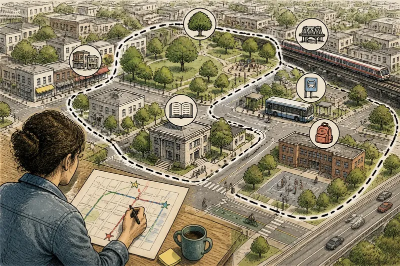
Ask two people where their neighbourhood ends, and they may point to different streets. A neighbourhood boundary is often a mental map: an informal edge shaped by the places you recognize, the routes you take, and the local names you use. Understanding that map helps explain why neighbors can share an address but imagine different communities.
What makes a neighbourhood feel like one place?
An official map divides a city into areas for administration, planning, or service delivery. The neighbourhood people carry in their heads is less tidy. It may include the bakery, bus stop, school, park, or corner where a familiar route changes character. Those places form a practical sense of “here,” even when no sign marks the edge.
This mental map is not simply a smaller version of a city map. It reflects repeated experience. A street someone crosses every day can feel central, while a nearby block they rarely visit may seem outside their orbit. The map is made from attention and habit as much as distance.
Think of it like a well-used key ring: the objects you reach for most often determine its everyday shape. In a similar way, recurring stops and routes give a neighbourhood its personal outline. Two residents can use the same streets yet carry different outlines because their routines differ.
How do landmarks create a mental edge?
Landmarks give people convenient reference points. A bridge, rail line, busy avenue, hillside, school, or cluster of shops can serve as a mental divider. Some landmarks feel like doors into another area; others act as anchors that pull nearby streets into the same neighbourhood.
Their meaning depends on how people encounter them. A major road may feel like a hard boundary to a pedestrian who seldom crosses it, but like a familiar connector to someone who walks across it on the way to work. A small park may draw residents from several surrounding blocks, making it a shared center rather than an edge.
Names matter, too. A place name heard at a library, on a storefront, or in a conversation may describe an area that differs from the district shown on a city map. People may also use a name for one commercial strip while applying it more broadly to the homes around it. These usages can coexist without one being a mistake.
Why do daily routes shape where home seems to end?
Routes turn a set of streets into a lived area. Someone who walks to a transit stop, buys groceries on the same avenue, and visits a nearby playground may experience those destinations as one continuous neighbourhood. Another resident, whose routine points toward a different shopping street or station, may picture a different center.
Barriers can alter that sense of continuity. A fence, steep slope, freeway, difficult crossing, or infrequent bus connection may make a nearby place feel remote. Conversely, a well-used path or direct transit link can make a farther destination feel closely connected. The map in a person’s head follows the effort and familiarity of getting somewhere, not just the line between two points.
Time can change the route map. A child’s school journey, a shift in a bus route, a new workplace, or a change in mobility can redirect familiar movement. The perceived neighbourhood may then expand, contract, or shift its center without any official boundary changing.
What do people really mean by a neighbourhood boundary?
Is a neighbourhood boundary the same as a city district?
Not necessarily. A district may have an official designation for planning or services, while a neighbourhood boundary may come from residents’ routines, landmarks, and local language. The two can overlap, but one does not automatically define the other.
Why can neighbors disagree about where their neighbourhood ends?
They may use different landmarks, travel different routes, or attach the neighbourhood name to different places. A resident who crosses a major avenue daily may see it as part of the area, while someone whose routine stops before it may treat it as an edge.
Can a neighbourhood boundary change without a formal decision?
Yes. Familiar routes and shared destinations can shift as people’s routines change. A new connection, a closed path, or a change in where residents gather may alter how the area is experienced even if official maps remain the same.
How can I describe my own neighbourhood boundary?
Name the landmarks and routes that make the area feel familiar, then identify where the journey begins to feel different. You can describe a soft edge, such as “around the park and the shops along the avenue,” instead of insisting on a precise line.
How can you compare two neighborhood maps without arguing?
Start by asking what each person is describing. They might mean the place they call home, the area they walk through regularly, or a named district used by a local institution. Once the purpose is clear, different boundaries become useful information rather than competing claims.
Say you live near a library and usually walk east to a grocery store, while a neighbor heads west to a transit stop. You might both describe your own routes on a simple paper map, marking familiar stops and the points where the area starts to feel unfamiliar. The expected result is not a single correct outline, but a visible explanation of how two experiences differ.
For a conversation with neighbors, a map can be a prompt rather than a verdict. Ask people to mark:
- Places they visit repeatedly and consider part of local life.
- Routes they use on foot, by bicycle, or on transit.
- Landmarks that draw people together or seem to divide areas.
- Streets or connections they rarely cross, and what makes them feel distant.
- Names they use for the area and where they have heard those names.
Look for patterns as well as differences. Several people may identify the same park as a center but describe opposite edges. Others may share a street name while assigning it different meanings. Asking why a place matters often reveals more than trying to settle on one boundary line.
When does a mental map matter to neighborhood life?
These informal maps affect how people talk about local identity and which places they treat as part of their everyday community. They can also help explain why a nearby destination feels accessible to one resident but out of reach to another. The difference may lie in a crossing, route, landmark, or habit—not in how many blocks separate them.
In neighborhood conversations, use terms such as “the area around the library” or “the streets I reach along this route” when a precise boundary is not shared. That wording keeps the discussion grounded in visible places and lets others explain their own map. If an official service or district boundary matters, check the relevant city map separately; a personal sense of neighborhood answers a different question.
The neighbourhood boundary you carry in your head is most useful when treated as a description of experience, not a claim that everyone must share. Notice the route or landmark that changes how a place feels, and you will have a clearer way to explain where your neighbourhood begins—and why someone else may draw it differently.